How Open Map Data is Helping Save Lives in Nepal
Nirab Pudasaini - June 15, 2015 in Data Stories, Fellowship
My name is Nirab Pudasaini, and I am a new School of Data fellow from Nepal. Just 5 days after the beginning of my fellowship, a devastating earthquake of magnitude 7.9 hit my country. It was on April 25th.
As of May 30 the death toll of the quake had risen to 8691 while 22054 were injured. In one district called Rasuwa, as much of 1.73% of the total population was injured. Nepal was hit bad by the earthquake and there was an immediate need to respond.
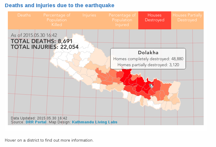
a map visualization showing the extent of the damage.
In the aftermath of the quake, national and international volunteers quickly joined forces to rescue people under debris, provide food and shelter to those who lost their home and generally provide relief to the affected communities. And the mapping effort was essential to this life-saving effort.
Mapping as a community effort
Crisis mapping, which has been the job of a few specialists in big NGOs like the Red Cross, has dramatically changed in the past few years. With the advent of the open source collaborative mapping project OpenStreetMap (OSM), and more recently the Humanitarian OpenStreetMap Team (HOT), thousands of volunteers contribute to the mapping of countries affected by disasters, with an unprecedented speed. By April 25, 5052 mappers had made 121525 edits to OpenStreetMap.
A part of this effort was shouldered by the non-profit tech organisation where I work, Kathmandu Living Labs. As part of this work, I spent the past two years building community around OpenStreetMap, with disaster resilience in mind.
With no detailed map of Nepal available, building a map with locals was the most efficient way to get there. Not only we were able to map Kathmandu in great detail, but all the school and health facilities in Kathmandu Valley along with their structural data was made freely available to everyone in OSM.
To make this work, we cannot expect to do all the work ourselves. So we train locals and empower communities so they can map their area themselves, using OSM. This way, we expanded our work to other cities than Kathmandu: Bharaptur, Hetaud, and villages like Bajrabarahi, Manahari and Padampur. The maps are used for many applications like agriculture, water health and sanitation and local governance. One of the major area is, of course, humanitarian use.
Data collection, needs assessment and supporting relief workers
Having centralised information proved to be a essential to help fill the information gaps during the earthquake crisis response. After the quake we have been focusing our efforts in four different tasks:
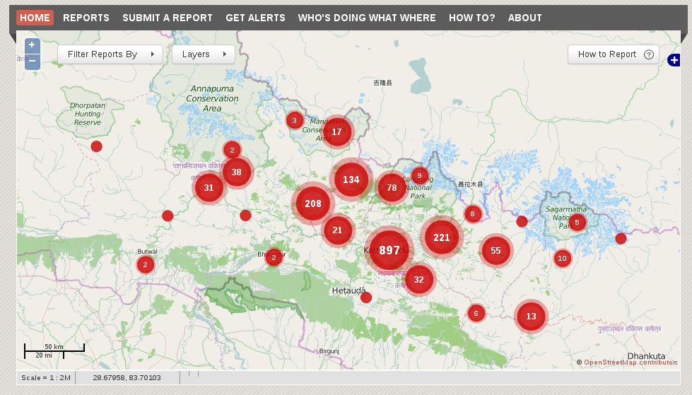
1) A platform where people can submit reports for earthquakes related needs: http://quakemap.org. 1800 reports have come into the system, which aggregates and display needs related to food, medicine, shelter, and sometimes evacuations. A team of volunteers verifies many of those needs, and signal them to appropriate responding organizations. Responding organizations can, and do subscribe to alerts for new reports that come into the system.
2) The collaboration with the international OSM community and Humanitarian OpenStreetMap Team to engage remote mappers. Mapper are given instructions on what and where to map, using the OSM tasking manager. The collaboration extends to satellite imagery providers to make aerial imagery available for post disaster mapping.
3) There is a huge need of data collection after the quake for the need assessment and planning. Data collection, storage and management is much easier, faster and cheaper when a mobile based digital solutions are used. We have developed a system using KLL Collect (a mobile app for data collection) which uses Ona’s Server and Dashboard solution to provide a complete data collection and storage solution. This is being used by various organization for their data collection needs.
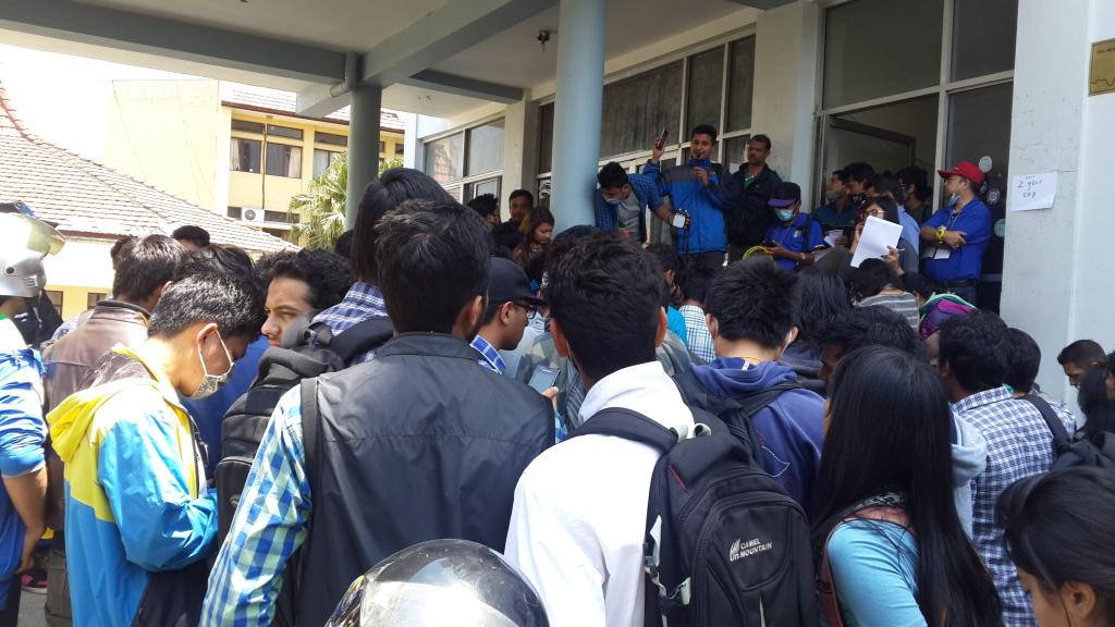
Me teaching Nepal Engineer Association volunteers about mobile data collection
4) http://quakerelief.info is a platform where we provide printable maps created with OSM data. The website provides instructions on using OSM data for Maps and Navigation without a mobile internet connection. The platform also contains useful digital maps like Deaths and Injuries from Earthquake for different districts, Earthquake Intensity by Population and more.
In the coming days information and maps will be playing a vital role in recovery and reconstruction. There are lots of challenges that needs to be overcome in the coming days but with challenges comes opportunity. Having adequate data in an understandable form will be important to plan for all the recovery and reconstruction work that will be done in Nepal and to capitalize those opportunities. Openly accessible map data will be for Nepal a vital piece of that information. As a 2015 School of Data fellow i will keep on working on making Maps for Nepal.
![]()